


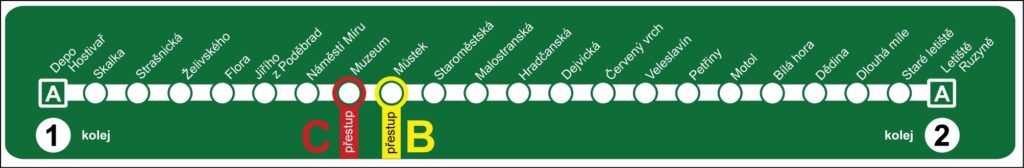
The Prague Metro map is one of the easiest public transport maps in Europe to understand. The system is built around three clearly marked lines that connect the city center with residential districts, transport hubs, and many popular tourist attractions.
Because of its simple layout and color-coded lines, even visitors using the metro for the first time can quickly learn how to navigate the system. The Prague Metro forms the backbone of the city’s public transport network and carries more than one million passengers every day.
Understanding how to read the Prague Metro map will help travelers move efficiently between major destinations such as Old Town, Wenceslas Square, Prague Castle, and many other locations across the city.
Quick Answer: How to Use Prague Metro Map in 30 Seconds
- 3 lines only: A-Green, B-Yellow, C-Red
- Check direction: Trains run toward terminal station like “Line A toward Depo Hostivař”
- Transfer here: Můstek A+B, Muzeum A+C, Florenc B+C
- Tourist stations: Staroměstská = Old Town, Malostranská = Castle
- Hours: 5:00 AM to midnight daily
Overview of the Prague Metro System
The Prague Metro consists of three lines identified by letters and colors. These lines intersect in the city center, allowing passengers to transfer easily between routes.
Prague Metro Map: 3 Lines Overview
The three metro lines are:
- Line A – Green
- Line B – Yellow
- Line C – Red
Together, these lines cover more than 60 kilometers of track and connect 61 stations across Prague. Most stations are located underground and can be reached using long escalators or elevators from the street level.
The metro system works together with Prague trams, Prague buses, and Prague trains, creating a fully integrated public transport network.
➤ If this is your first time using Prague’s underground transport system, you may want to read our detailed guide on How to Use the Prague Metro.
Understanding the Prague Metro Lines

Line A vs Line B vs Line C Quick Table
| Line | Color | Route | Best For Tourists |
|---|---|---|---|
| Line A | Green | Nemocnice Motol → Depo Hostivař | Old Town, Castle, Wenceslas Square |
| Line B | Yellow | Zličín → Černý Most | Shopping, Anděl, Florenc bus |
| Line C | Red | Letňany → Háje | Airport bus, Vyšehrad, main station |
🟢 Line A – Green Line
Line A runs from Nemocnice Motol in the west to Depo Hostivař in the east.
This line is particularly useful for tourists because it passes near several important attractions in the historic center.
Important stations include:
- Malostranská – access to Prague Castle and Lesser Town
- Staroměstská – near Old Town Square and the Astronomical Clock
- Můstek – located at the bottom of Wenceslas Square
- Muzeum – near the National Museum
Because of its central route, Line A is often considered the most tourist-friendly metro line in Prague.
🟡 Line B (Yellow Line)
Line B is the longest metro line in Prague. It runs from Zličín in the west to Černý Most in the northeast.
On the Prague Metro map, Line B is the longest colored line running east-west across the city.
This line connects several busy commercial and residential areas of the city.
Major stations include:
- Náměstí Republiky – near the Palladium shopping center
- Anděl – a major shopping and business district
- Můstek – transfer station to Line A
- Florenc – transfer station to Line C and the central bus station
🔴 Line C (Red Line)
Line C runs from Letňany in the north to Háje in the south.
You’ll see Line C marked in red on every metro map of Prague at stations and platforms.
This line connects residential neighborhoods with the city center and several major transport hubs.
Key stations include:
- Florenc – transfer to Line B
- Muzeum – transfer to Line A
- Vyšehrad – near the historic Vyšehrad fortress and park
Major Transfer Stations on the Prague Metro Map
The Prague Metro map includes several stations where passengers can transfer between lines. These transfer points are located in the city center and play an important role in navigating the network.
Tourist Mistakes at Transfer Stations
Můstek
Můstek connects Line A and Line B. It is located near the lower end of Wenceslas Square and is one of the busiest stations in Prague.
Muzeum
Muzeum connects Line A and Line C. The station sits next to the National Museum and at the top of Wenceslas Square.
Florenc
Florenc connects Line B and Line C and is located near Prague’s main international bus station.
Staroměstská
Staroměstská is located on Line A and provides easy access to Old Town Square and Charles Bridge.
How to Read the Prague Metro Map
Understanding the Prague Metro map is simple once you know the basic elements.

Identify the Line Colors
Each metro line has a specific color:
- Green – Line A
- Yellow – Line B
- Red – Line C
These colors are used consistently on maps, station signs, and metro trains.
Check the Terminal Stations
Metro trains run toward the terminal station at the end of the line. Platform signs display the name of the final station to indicate the train direction.
For example:
- Line C toward Letňany
- Line C toward Háje
At Vltavská station on Prague Metro Line C, trains run in two directions: toward Letňany or toward Háje. Passengers should check the platform signs to make sure they board the train going in the correct direction.
Look for Transfer Points
If your journey requires switching lines, the map clearly shows transfer stations such as Můstek, Muzeum, and Florenc.
Prague Metro Operating Hours
The Prague Metro map shows the system operates daily from 5:00 AM until midnight.
Train frequency depends on the time of day:
- 2–3 minutes during rush hours
- 4–6 minutes during normal daytime hours
- 7–10 minutes late in the evening
After midnight, Prague relies on its night tram network, which connects many metro stations and continues operating throughout the night.
Tips for Tourists Using the Prague Metro Map
Visitors can follow a few simple tips to navigate the metro more easily.
Always Check the Direction
Platforms are marked with the name of the terminal station, which indicates the direction of travel.
Follow the Signs
Metro stations include clear signs showing line colors, transfers, and exits, making it easy to move through the system.
Combine the Metro with Trams
Some destinations are easier to reach by tram after leaving the metro.
For example, visitors often take the metro to Malostranská and then use tram 22 to reach Prague Castle.
Keep a Metro Map on Your Phone
Many travelers keep a digital Prague Metro map on their smartphone so they can quickly check routes while exploring the city.
Where to Find the Prague Metro Map
Travelers can easily obtain the Prague Metro map in several places.
Common options include:
- Official PDF: Download free map from DPP.cz official site
- Tourist information centers
- Hotels and hostels
- Metro stations
- Mobile transport apps
Many websites also offer Downloadable PDF Versions of the Metro Map, allowing travelers to access it even without an internet connection.
Why the Prague Metro Is Popular with Visitors
The Prague Metro is widely considered one of the most efficient and tourist-friendly metro systems in Europe.
Despite having only three lines, it connects most important districts and attractions.
The metro is also known for:
- Fast travel across the city
- Clean and safe stations
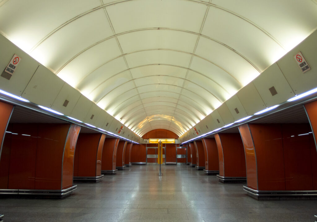
- Distinctive underground architecture
- Clear signage in Czech and English
Because of these advantages, both residents and tourists rely on the metro for daily transportation.
Prague Metro Map FAQs 2026
Yes. The Prague Metro map is one of the simplest in Europe with only 3 lines: A-Green, B-Yellow, C-Red. All signs are in Czech + English, and transfer stations Můstek, Muzeum, Florenc are clearly marked. First-time visitors usually learn it in 2 minutes.
Take Line A – Green and get off at Staroměstská station. From there Old Town Square + Astronomical Clock are 2 minutes walk. This is the most used tourist stop on the Prague Metro map.
The 3 main transfer stations are: Můstek – Line A ↔ Line B – Muzeum – Line A ↔ Line C – Florenc – Line B ↔ Line C – All 3 are in the city center and connect to major attractions.
Yes. You can download the official Prague Metro map PDF 2026 for free from DPP.cz, Prague’s public transport website. Save it offline – metro stations have weak mobile signal underground.
Prague Metro runs daily from 5:00 AM to midnight. After midnight, night trams take over and connect most metro stations. Frequency is 2-3 min rush hour, 4-6 min daytime
Final Thoughts
The Prague Metro map provides a simple and efficient way to navigate the city’s public transport system. With its three color-coded lines, central transfer stations, and clear design, the metro network is easy to understand even for first-time visitors.
By learning how to read the map, checking train directions, and using the transfer stations, travelers can quickly move between Prague’s major attractions and neighborhoods.
Whether you are visiting the historic Old Town, exploring Wenceslas Square, or heading toward Prague Castle, the Prague Metro remains one of the fastest and most convenient ways to travel across the city.
 Transport Type: Metro (Subway)
 City: Prague, Czech Republic
 Metro Lines: A, B, C
 Lines Colors: Green, Yellow, Red
 Total Stations: 61
 Network Length: Approx 65 km
 Opening Year: 1974
 Peak Hours Frequency
 Off-Peak Frequency